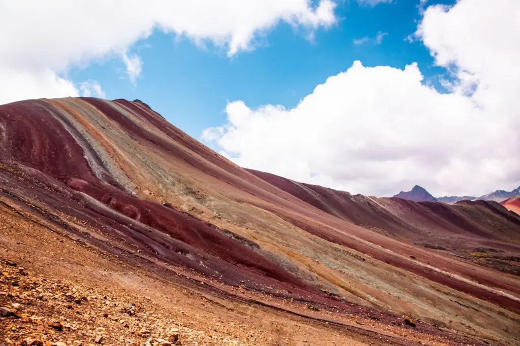
Rainbow Mountain Peru is best visited between April and September, and the July and August crowds are worth avoiding if your dates allow. Altitude is the main challenge on the trek to Vinicunca, so acclimatize in Cusco before you climb.
Vinicunca is one of the standout stops on any list of the best adventure travel destinations. The sections below explain how elevation shapes the hike, which months suit it, how to get to the trailhead, what to ask about costs, and which warning signs mean you should turn around.
Where Vinicunca sits and why altitude sets the difficulty
Vinicunca stands at 5,200 m (17,060 ft) above sea level, and Explorer’s Passage notes that the whole trek is done above 15,000 ft (4,572 m). Cusco, where most visitors begin, already sits at 3,399 m (11,152 ft). The hike is short in hours but demanding in oxygen terms. How well you have adjusted to elevation matters more than how quickly you can walk.
Location and setting
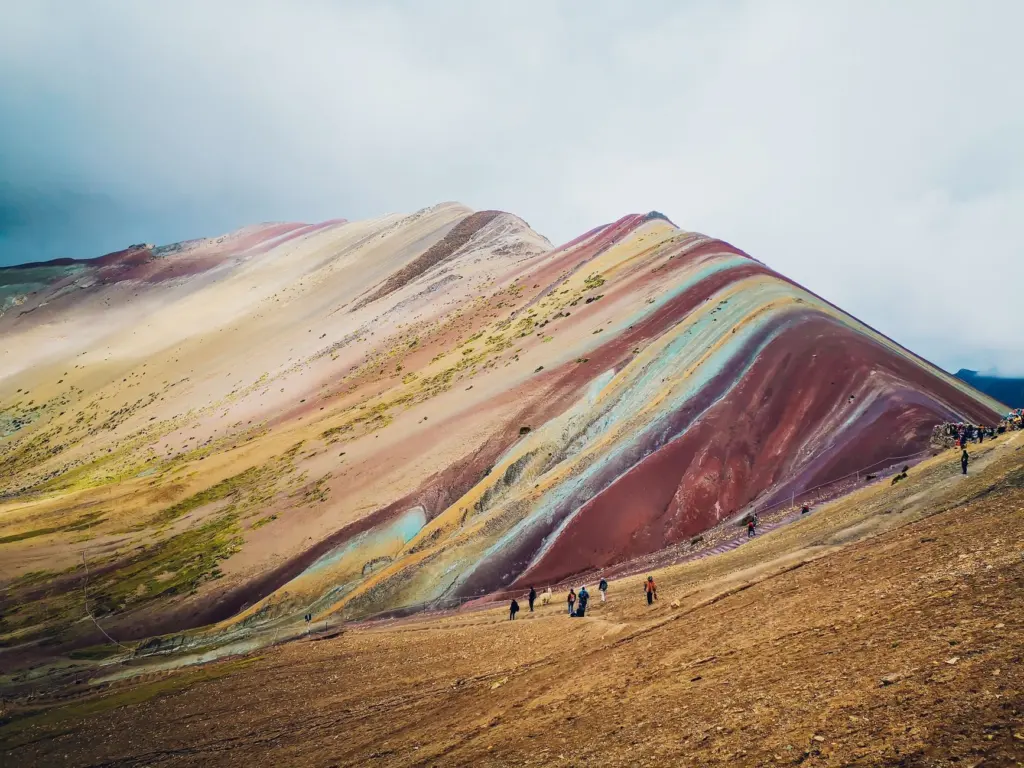
Vinicunca lies about 100 km southeast of Cusco, according to Trexperience Peru. The same source names Ausangate, at 6,385 m, as the highest peak in the area, so the striped slope sits beneath a much larger snow-capped skyline. It also describes Vinicunca as the second most visited tourist destination in Peru after Machu Picchu, which is why timing matters for crowds.
| Feature | Value | Planning use |
|---|---|---|
| Vinicunca summit | 5,200 m (17,060 ft) | The high point of the day. Expect thin air at the top. |
| Trek altitude | Above 4,572 m (15,000 ft) throughout | There is no low-altitude stretch to recover on. |
| Cusco | 3,399 m (11,152 ft) | Use the city as your acclimatization base. |
| Distance from Cusco | About 100 km southeast | This is a full-day excursion, not a quick hop. |
| Drive to trailhead | About 3 hours from Cusco | Plan an early departure and a long day. |
| Return hike | About 3 to 4 hours | Allow extra time for rest stops and photos. |
| Ausangate | 6,385 m | The dominant peak visible near Vinicunca. |
These figures come from Explorer’s Passage and Trexperience Peru.
Best time to visit Rainbow Mountain
The most dependable window is April to September. That range sits inside both recommendations in the sources, and it lets you avoid the busiest weeks if you plan with crowds in mind.
Which months to choose
Explorer’s Passage suggests planning your trip for the months between March and September. Trexperience Peru adds that conditions are often clearer between April and October. Overlapping the two gives April to September as the safest range. March and October are still reasonable, but each is backed by only one of the two recommendations, so treat them as the edges of the season.
Crowds in peak season
July and August bring large crowds of up to 3,000 people each day, according to Explorer’s Passage. If your dates are flexible, April, May, June and September all fall inside the recommended windows and outside that July and August peak. If you can only travel in July or August, book a firm departure and expect to share the viewpoint.
Weather on the day
Trexperience Peru warns that weather at this altitude can change quickly, so warm layers and waterproof clothing belong in your bag at any time of year. A good month improves your odds of a clear view but never guarantees one. Build a spare day into your Cusco stay rather than treating a single morning as your only chance.
Getting to the trailhead and walking the trail
Most visitors reach the trail from Cusco. Explorer’s Passage describes a 3-hour drive south from Cusco to the trailhead in Pitumarca. Trexperience Peru describes a newer route that also takes around 3 hours to reach the trailhead, with an easier hike. Ask your operator which route and trailhead they use, because it changes how much of the effort you face on foot.
How hard is the hike?
The return hike takes around three to four hours, according to Explorer’s Passage. That makes it short on the clock, and the difficulty comes almost entirely from elevation, since the whole route is above 4,572 m. Walk at a pace that lets you talk, pause often, and treat any headache or dizziness as a reason to slow down, not a hurdle to push through. First-time visitors who have spent nights at altitude beforehand will find the same trail far more manageable than those arriving straight from sea level.
Entrance ticket and tour costs
A local entrance ticket is required, and some tour operators include it in the price while others charge it separately. The total cost of a visit therefore depends on the operator you choose and on what the quote covers, such as transport from Cusco, the ticket and a guide. When you compare quotes, ask each operator the same questions so you are comparing like with like. A cheaper headline price may simply leave the entrance ticket for you to pay on the day.
Acclimatizing and recognizing altitude sickness
Altitude sickness is the main health risk on the route, and the best precaution is time. Trexperience Peru advises spending two or three nights adjusting to the altitude before going higher. Since Cusco is already at 3,399 m, according to Explorer’s Passage, treat the city as your first step and keep Vinicunca for later in the stay, not your first morning in Peru.
Symptoms that mean you should stop
If you experience headaches, nausea, dizziness or unusual tiredness, do not push yourself to complete the hike. Tell your guide early, rest, and decide whether to continue only once the symptoms ease. Turning back with a view unseen is a far better outcome than pressing on.
Signs that require descent
Vomiting, confusion, poor coordination or difficulty breathing at rest are more serious. The same source says the affected person should descend and seek medical attention. Group members should watch one another for these signs, because confusion and poor coordination can make it hard to judge your own condition.
Alternatives and companion plans around Cusco
If the altitude or the crowds put you off, Palcoyo is located 20 kilometers south of Classic Rainbow Mountain and gives you a different coloured-mountain stop in the same region. It is worth asking your operator about as a substitute.
Vinicunca also fits into a wider Cusco itinerary. The Sacred Valley, Peru: Your Practical Guide To History, Hiking, And Hidden Gems In 2026 covers the history and walking around the valley. For a structured day out from Cusco, the Sacred Valley Tour From Cusco: The Complete One‑Day Itinerary And Practical Guide (2026) lays out how the day runs. Putting those days before Vinicunca gives you time to settle into the altitude first.
Frequently asked questions
Should I see a doctor before going?
Anyone with heart or respiratory conditions should speak with a healthcare professional before traveling, according to Trexperience Peru.
Do I need cash for the visit?
Yes, it is useful to carry some Peruvian soles in cash, particularly if your tour does not include the entrance ticket.
Are there shops and facilities on the upper trail?
No. Services near the upper section of the trail are limited and are mainly available in Pitumarca, so bring the water, layers and supplies you will need before you start walking.